ONABARA
Category: Ancient City
Civilisation: Lycia
ONABARA
Ancient Lycian City
Onobara (Όνόβαρα) was a town of ancient Lycia, which per the Stadiasmus Patarensis was the destination of a road from Trabenna. Its site is located near Göderler, Asiatic Turkey.
The Stadiasmus Patarensis, also known as the Stadiasmus.

Outdoor Tracking Route
by wikiloc
The Stadiasmus Patarensis, also known as the Stadiasmus Provinciae Lyciae and the Miliarium Lyciae, is an ancient Roman milestone from the city of Patara. The stadiasmus, shaped as a pillar, served as a monumental public itinerarium. It has a Greek inscription with a dedication to Claudius and an official announcement of roads being built by the governor, Quintus Veranius Nepos, in the province of Lycia et Pamphylia, giving place names and distances. It was discovered in 1993. It has been dated to the year 46 AD


The settlement’s name was first determined by Heberdey and Kallinka on their visit; later it was visited by Antiand Viale who identified new inscriptions. This site was also mentioned in modern studies conducted without legal permission, This site was surveyed in all its detail for the first time by our team during which evidence regarding the southern border of the territory of Trebenna was found and archaeologists have determined that this small settlement was a katoikia under Trebenna.Its name possibly comes from ono (donkey) and baris (farm). The sarcophagi in the farmsscattered around in the vicinity of Onobara clearly indicate that Onobara was not only atown centre, but that these nearby farms were within the territory of Onobara, which wasin its turn within the territory of Trebenna. The largest is the settlement at Deveboynu andthe farms at Gedeller are also within the territory of Onobara.

Onobara was thename of not only of the settlement but also of the farms around. The difference in opinionlies in which was the central settlement, as Viale proposed that the entire Gökdere val-ley was Onobara and the centre was the farm at Gedeller, while the others, agreed the entire Gökdere valley was Onobara but considers Deveboynu was the centre. The richremains discovered in the site surveys as well as the numerous inscribed blocks, have clearly shown that Onobara was the farms in the Gökdere valley and that the central settlement is at Deveboynu. To the south of the hill upon which the settlement is located, a border inscription was found which clarified the border between Phaselis and Trebenna. According to the Miliarium Lyciae,Onobara is the last point having connection with the sea as it connects to thalasa (sea).Therefore, it must have been one of the routes through which products coming from themountains behind were shipped via sea for sale.


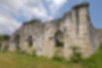
The visible remains in the town centre belong to the Roman and Byzantine peri-ods. Almost all of the building material is Roman but the buildings’ last phases indicateByzantine use and the Byzantine building with three rooms built from Roman spolia isnoteworthy. There are three more rooms placed in the east-west direction, just below thisByzantine building. To the east of these buildings there is a row of rooms extending paral-lel to the slope. This area was suitable for the Roman settlement’s square, i.e. the agora,understood to have been heavily rebuilt from Roman spolia during the Byzantine period.
During surveys 18 inscribed blocks were found. In the centre are four sarcophagus podiums withlion paws, one ostothek piece, a small altar with a lightning motif in relief and half of asundial. Furthermore, some profiled blocks with slight curvature indicate the former pres-ence of an exedra. Other architectural blocks reveal information regarding the buildingsof the Roman period town. It is thought that some of the honorary inscriptions were origi-nally placed on a monumental gateway. Because all of the buildings underwent significantmodifications during the Byzantine period with their material re-used elsewhere, it is very difficult to determine the plans and precise functions of these buildings. The most impor-tant building dating from the Byzantine period is a well-preserved small church.
A rock-cut inscription was discovered at Gavurbeleni. This rock-cut inscription comprises the initials of the names of two citiesand marks the border between Onobara and Trebenna, or between Typallia and Onobara.The inscription reads OTO and here O is certainly to be identified with Onobara but we are not sure whether T stands for Trebenna or Typallia.

References:
1-https://en.wikipedia.org/wiki/Onobara
2-Çevik, Nevzat (2008). "Northeast Lycia. The New Evidence - The Results from the past ten years from the Bey Mountains Surface Surveys"
4-wikipedia.org/wiki/Stadiasmus_Patarensis
5-Hiking-022 Gedeller - Gökdere-Onobara Antik kenti-Tünektepe Sarısu Likya yolu (Lyciaway) / Antalya